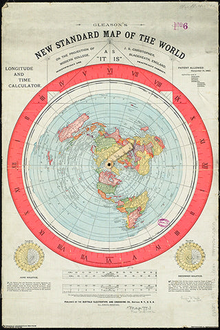
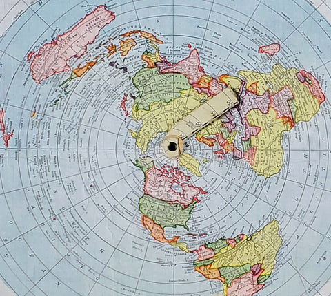
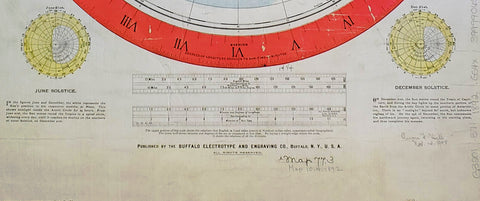
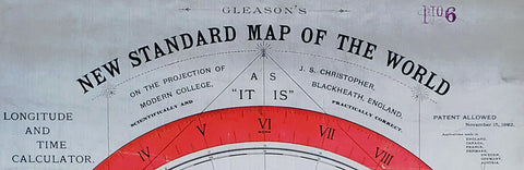
Gleason's New Standard MAP OF THE WORLD (1892) 24x36 Wall POSTER Reproduction - Posterservice Inc. 2020
Item #: PS-11565
Shop for more related posters in these collections:
We Also Recommend
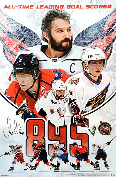
Alex Ovechkin NHL's All-Time Leading Goal Scorer Washington Capitals Commemorative Poster - Costacos 2025
Item # CN26704-25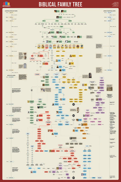
Biblical Family Tree and Historical Timeline Wall Chart Premium Reference Poster - Useful Charts
Item # UC-17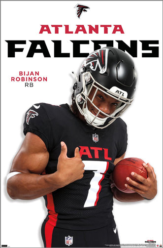
Bijan Robinson "Superstar" Atlanta Falcons NFL Action Poster - Costacos 2024
Item # CN25454-24
Caitlin Clark Indiana Fever 2024 WNBA Rookie of the Year Commemorative Poster - Costacos Sports
Item # CN26065-24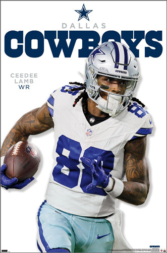
CeeDee Lamb "Trailblazer" Dallas Cowboys NFL Action Poster - Costacos 2024
Item # CN25459-24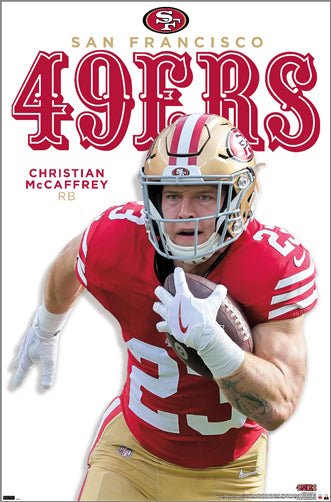
Christian McCaffrey "Superstar" San Francisco 49ers NFL Action Wall Poster - Costacos 2024
Item # CN25478-24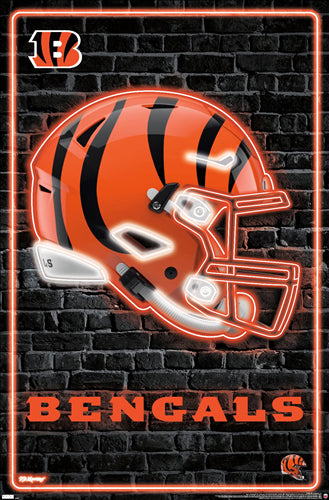
Cincinnati Bengals Official NFL Football Team Helmet Logo Neon-Style Poster - Costacos Sports
Item # CN23838-23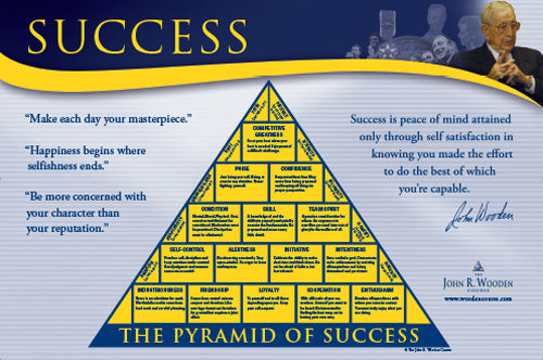
Coach John Wooden's "Pyramid of Success" Motivational Inspirational Wall Poster - Classic Edition
Item # JWC-01-CL
Coach John Wooden's "Pyramid of Success" Motivational Inspirational Wall Poster - Executive Edition
Item # JWC-01
COMBO: Lionel Messi Inter Miami CF Official MLS Soccer Action 2-Poster Combo Set
Item # PSAC-129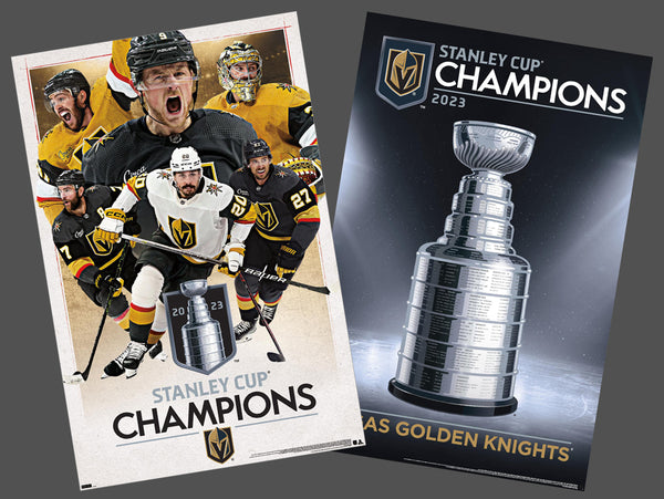
COMBO: Vegas Golden Knights 2023 Stanley Cup Champions Commemorative 2-Poster Set - Costacos Sports
Item # CN23052-23053
Connor McDavid "Superstar" Edmonton Oilers NHL Hockey Poster - Costacos Sports 2022
Item # CN22885-22
Dak Prescott "Lone Star Great" Dallas Cowboys QB NFL Action Poster - Costacos Sports 2022
Item # CN22714-22
Denver Nuggets 2023 NBA Champions Official Commemorative Poster - Costacos Sports
Item # CN23048-23Detroit Lions Official NFL Football Team Helmet Logo Neon-Style Poster - Costacos Sports
Item # CN23842-23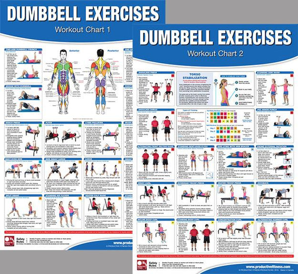
Dumbbell Exercises Workout 2-Poster Professional Wall Chart Combo - Productive Fitness
Item # PFP-DUMBELLS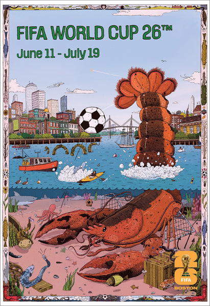
FIFA World Cup 2026 Host City Boston Official 24x36 Event Poster - MPW
Item # MPW-147946
Fitness Gym Motivational "Challenge Your Limits" Inspirational Quotes Wall Poster - Trends Int'l.
Item # CN15817-17
Ford F-150 F-Series Pickup Truck Evolution (26 Models Since 1948) Autophile Poster - Eurographics
Item # EU2400-0950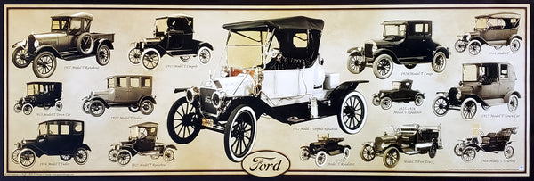
Ford Model T Automobiles (1908-1927) Official Ford Motor Company Commemorative Poster - Aquarius
Item # SB-P2030
Ford Mustang "Evolution" (29 Classic American Muscle Cars) Poster - Eurographics
Item # EU2450-0684Green Bay Packers Official NFL Football Team Helmet Logo Neon-Style Poster - Costacos Sports
Item # CN23843-23
Inter Miami CF 2025 MLS Cup Champions Official Commemorative Poster - Costacos 2025
Item # CN26557-25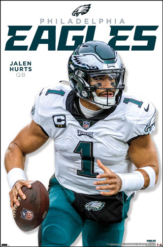
Jalen Hurts "Roll Out" Philadelphia Eagles QB NFL Action Wall Poster - Costacos 2023
Item # CN23943-23
Jayden Daniels "Dynamo" Washington Commanders Official NFL Football Wall Poster - Costacos 2024
Item # CN26236-25
Josh Allen "Touchdown Roar" Buffalo Bills QB NFL Action NFL Poster - Costacos 2023
Item # CN23937-23
Kansas City Chiefs Super Bowl LVII (2023) CHAMPIONS 6-Player Commemorative Poster - Costacos
Item # CN22969-23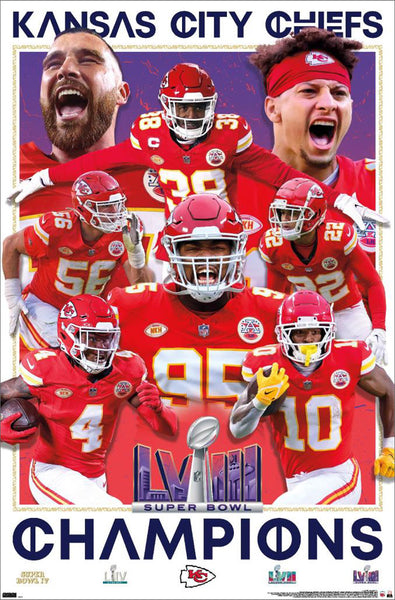
Kansas City Chiefs Super Bowl LVIII (2024) CHAMPIONS 8-Player Commemorative Poster - Costacos
Item # CN23874-24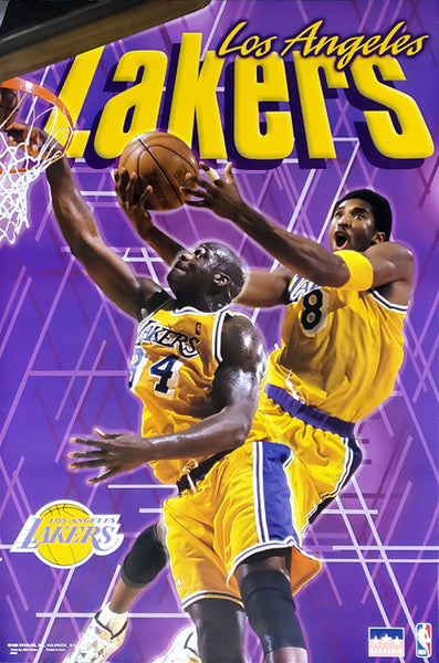
Kobe Bryant and Shaquille O'Neal "Showtime" Los Angeles Lakers Poster - Starline 1999
Item # S3568
Kylian Mbappé "Superstar" Real Madrid CF Official La Liga Football Action 24x36 Poster - Grupo Erik (Spain)
Item # GE-GPE6028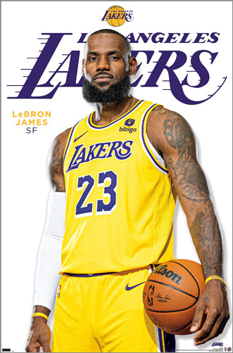
LeBron James "Legend" Los Angeles Lakers Official NBA Poster - Costacos Sports
Item # CN24074-23
LeBron James "Showtime 6" Los Angeles Lakers Official NBA Poster - Costacos 2022
Item # CN22691-22
Lionel Messi "Dynamo" Inter Miami CF MLS Soccer Action Poster - Costacos 2026
Item # CN27429-26
Lionel Messi "In Action" Inter Miami CF MLS Soccer Poster - Costacos 2025
Item # CN26226-25
Lionel Messi "Passion For The Game" Inter Miami CF MLS Soccer Poster - Costacos 2025
Item # CN26227-25Los Angeles Chargers Official NFL Football Team Helmet Logo Neon-Style Poster - Costacos Sports
Item # CN23849-23
Luka Doncic "Golden Star" Los Angeles Lakers Official NBA Basketball Action Poster - Costacos 2025
Item # CN26475-25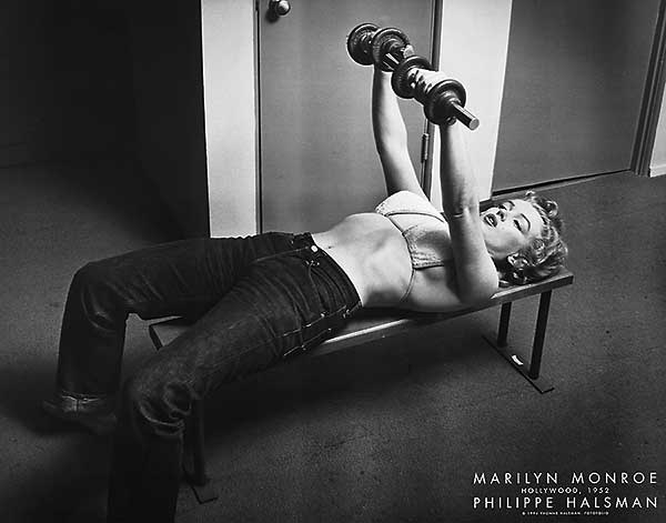
Marilyn Monroe "Pumping Iron" (Hollywood 1952) Poster Print - Image Conscious.
Item # IC-H353
Maxx Crosby "Superstar" Las Vegas Raiders NFL Action Wall Poster - Costacos 2024
Item # CN25466-24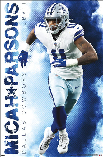
Micah Parsons "Prowler" Dallas Cowboys Linebacker NFL Action Poster - Costacos Sports 2022
Item # CN22653-22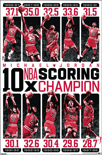
Michael Jordan "10-Time NBA Scoring Champion" Chicago Bulls Commemorative NBA Poster - Costacos Sports 2025
Item # CN27293-25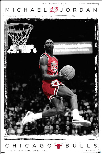
Michael Jordan "1987 Slam Dunk Classic" Chicago Bulls Commemorative NBA Poster - Costacos Sports 2022
Item # CN21923-22
Michael Jordan "23 Soaring Slam" Chicago Bulls Commemorative NBA Poster - Costacos Sports 2022
Item # CN21928-22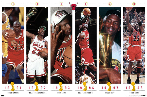
Michael Jordan "Championship History" Chicago Bulls Commemorative NBA Poster - Costacos Sports 2023
Item # CN24362-23
Michael Jordan "Cloudburst" Chicago Bulls Commemorative NBA Basketball Action Poster - Costacos Sports 2023
Item # CN23327-23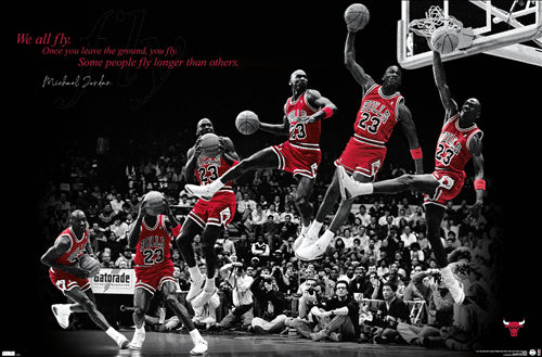
Michael Jordan "Fly" Chicago Bulls Slam Dunk Inspirational NBA Poster - Costacos Sports 2022
Item # CN21927-22
Michael Jordan "Pinstripes Slam" Chicago Bulls Commemorative NBA Poster - Costacos Sports
Item # CN21929-22
Michael Jordan "Six-Foot Slam" Chicago Bulls HUGE Door-Sized Poster - Costacos 1997
Item # CN8364-97
Michigan Wolverines 2026 NCAA Basketball Champions Commemorative 24x36 Poster - ProGraphs Inc.
Item # PG-089Minnesota Vikings Official NFL Football Team Helmet Logo Neon-Style Poster - Costacos Sports
Item # CN23852-23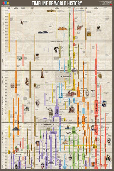
Timeline of World History (Human Civilization from 3,000 BCE to Present) Premium Wall Chart Poster
Item # UC-01
Steve Prefontaine "The Gift" c.1972 Motivational Action Poster - Running Past
Item # RP001
Coach John Wooden's "Pyramid of Success" Motivational Inspirational Wall Poster - Executive Edition
Item # JWC-01
UFC Bicentennial Commemorative Poster (Poster Thumbnails #1-200) - Pyramid America
Item # PP-PAS0999
Fitness Gym Motivational "Challenge Your Limits" Inspirational Quotes Wall Poster - Trends Int'l.
Item # CN15817-17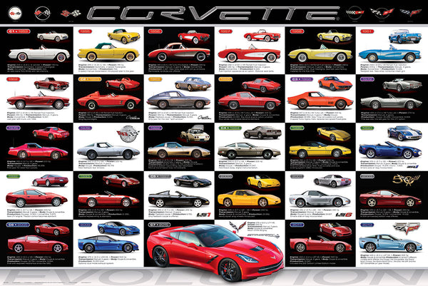
Chevrolet Corvette Evolution (29 Classic Sportscars) Official Automobile History 24x36 Wall Poster - Eurographics
Item # EU2450-0683
Combo: The Pro Sports Universe (NFL, MLB, NHL, NBA Logos) All Team Logos 4-Poster Set - Costacos Sports
Item # PSAC-001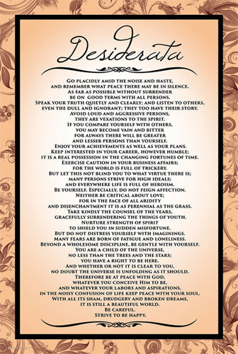
Desiderata Inspirational Life Advice Poem 24x36 Wall Poster - Posterservice Inc.
Item # PS-10415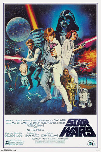
Star Wars Episode IV (1977) Official One-Sheet Movie Poster 24x36 Reproduction - Trends International
Item # CN14810-16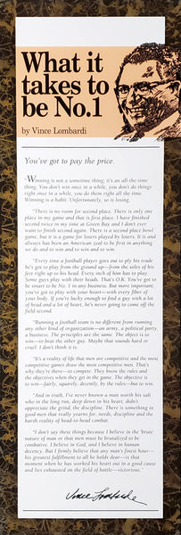
Vince Lombardi "What it Takes to Be Number One" Inspirational Poster
Item # IC-L179
Marilyn Monroe "Pumping Iron" (Hollywood 1952) Poster Print - Image Conscious.
Item # IC-H353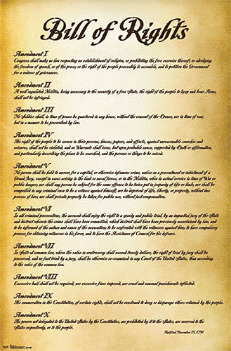
The Bill of Rights (First Ten Amendments to the United States Constitution) Poster - Trends International
Item # CN6908-13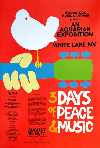
Woodstock 1969 Original Festival Bill Poster Reproduction - Aquarius 2009
Item # AQ-24772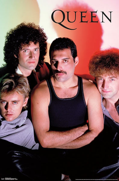
Queen (Freddie Mercury, Brian May, John Deacon, Robert Taylor) "Classic 1984" Rock Band Group Poster - Trends International
Item # CN16982-19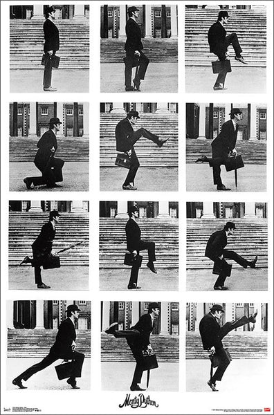
Monty Python's Ministry of Silly Walks (John Cleese) Classic Comedy Sketch Poster - Trends International
Item # CN17222-19
Tiger Woods "Always Get Better" Golf Action Inspirational Poster - Costacos Sports/Upper Deck
Item # CN22009-22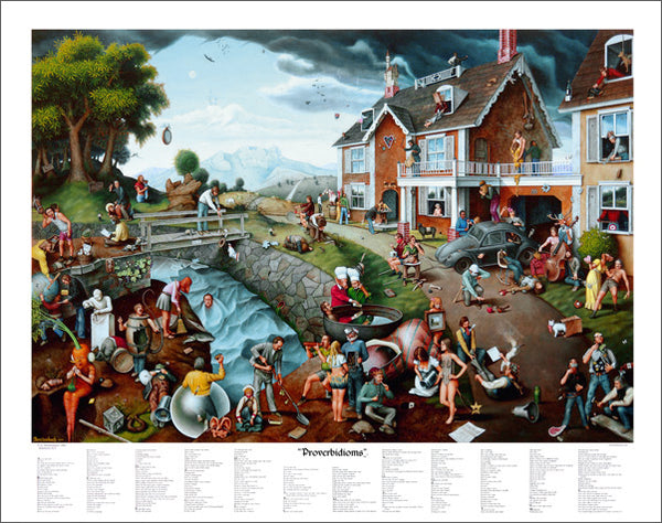
Proverbidioms by T.E. Breitenbach Official 22x28 Poster Print
Item # BREIT-01
Fantasy Concert Poster: The Beatles "Get Back Tour" at the Hollywood Bowl
Item # BT-6375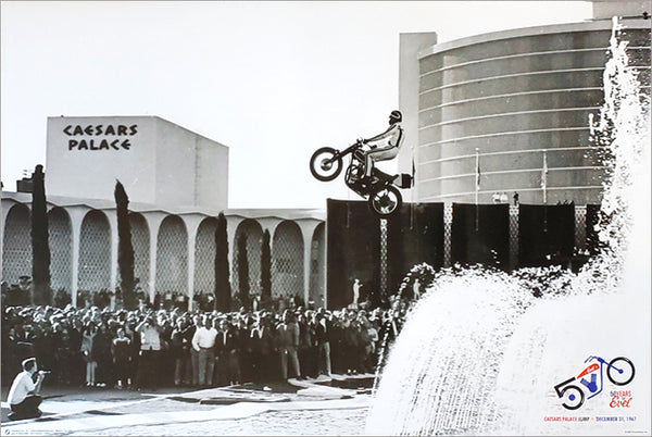
Evel Knievel Caesars Palace Fountain Jump 1967 Historic Daredevil Poster - Posterservice
Item # PS-10960
Surfing Caravan (Volkswagen Buses at the California Beach) HUGE Wall-Sized Poster - GB Eye
Item # GB-DP0369
The Rat Pack "Eight-Ball" Classic Black-and-White Billiards Pool Poster - WCI Posters
Item # II-ST2757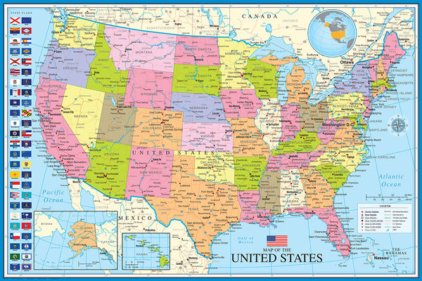
Map of The United States of America USA 24x36 Wall Poster - Eurographics Inc.
Item # EU2400-0788
THE SIMPSONS UNIVERSE (400 Characters) Official TV Animated Series 24x36 Poster - Grupo Erik Editores
Item # GE-GPE5921
Metallica In Concert Metal Rock Band Official 24x36 Wall Poster - Pyramid America 2020
Item # PP-PAS1973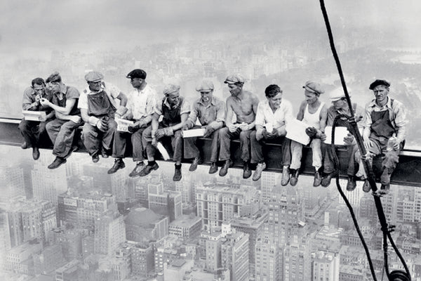
Rockefeller Center 1932 "Lunch on a Skyscraper" Poster Print (Charles C. Ebbets) - Eurographics Inc.
Item # EU2400-4372
Coach John Wooden's "Pyramid of Success" Motivational Inspirational Wall Poster - Classic Edition
Item # JWC-01-CL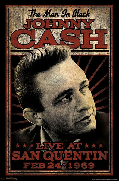
Johnny Cash "San Quentin 1969" Classic Music Poster - Trends International
Item # CN17766-19
Conor McGregor "NOTORIOUS" (In the Octagon) UFC Superstar Wall POSTER - Pyramid Posters
Item # PP34058
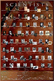
Famous Scientists Historical Educational Wall Chart Poster - Eurographics Inc.
Item # EU2450-2000
Danica Patrick "Slick" (B&W) Racing Superstar Poster - Time Factory
Item # TF-8513
I Will Be (78 Adjectives for Success) Inspirational Poster - Wizard and Genius
Item # WG-1544
Adorable Kitten "Hang In There" Super-Cute Cat Poster - Trends International
Item # CN14200-15
Legends Poker Fantasy "Royal Flush" Poster Print by Chris Consani - Jadei Graphics
Item # IC-C1096D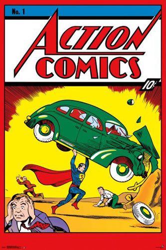
Action Comics #1 (Superman Debut June 1938) DC Comics Cover 24x36 Poster Reproduction - Trends
Item # CN13753-21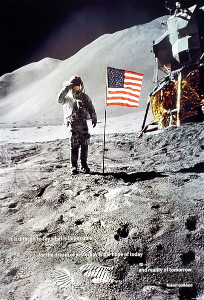
Neil Armstrong Apollo 11 Moon Landing 1969 "Reality of Tomorrow" Poster - ISI
Item # IS-36506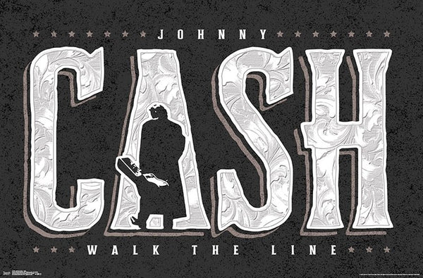
Johnny Cash "Walk the Line" Classic Music Poster - Trends International
Item # CN17765-19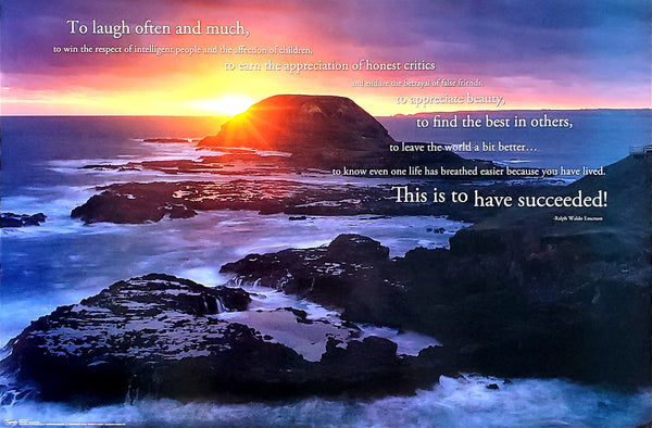
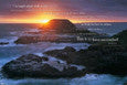
Success in Life (Ralph Waldo Emerson Quote) Sunset at Rocky Ocean Coast Inspirational Poster - Trends International
Item # CN9417
Maria Sharapova "Game, Set, Match" Tennis Poster - Ace Authentic
Item # AA-2006
Music Will Set You Free Inspirational Guitar Poster - Trends International Inc.
Item # CN17046-18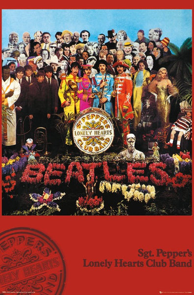
The Beatles Sgt Pepper's Lonely Hearts Club Band (1967) Album Cover Poster - GB Eye (UK)
Item # GB-LP0905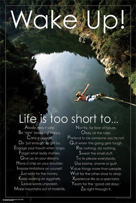
Wake Up! Motivational Inspirational Poster (Bungee Jumping) - Posterservice
Item # PS-9670
Ultimate Supercar Garage "Justification for Higher Education" Poster - Pyramid America
Item # PP-PAS0166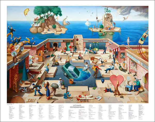
Ultimate Proverbidioms by T.E. Breitenbach Official 22x28 Poster Print
Item # BREIT-02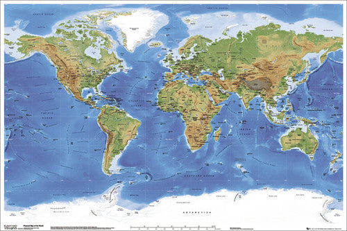
Planetary Visions Physical Map of the World (Miller Cylindrical Projection) Wall POSTER - GB Eye
Item # GB-GN0394
The Coffee Poster (27 Classic Coffee Shop Drinks) - Eurographics Inc.
Item # EU2400-0589
Proverbidioms IV by T.E. Breitenbach Official 22x28 Poster Print
Item # BREIT-07
Farrah Fawcett Red Swimsuit 1976 Poster 24x36 Reproduction - Studio B/Farrah Fawcett Foundation 2023
Item # SB-P9566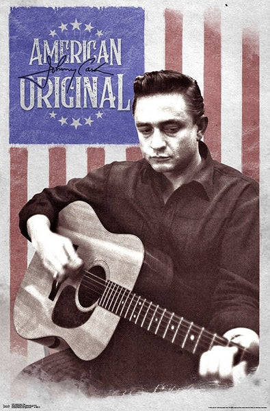
Johnny Cash "American Original" Classic Music Poster - Trends International
Item # CN17767-19
Timeline of World History (Human Civilization from 3,000 BCE to Present) Premium Wall Chart Poster
Item # UC-01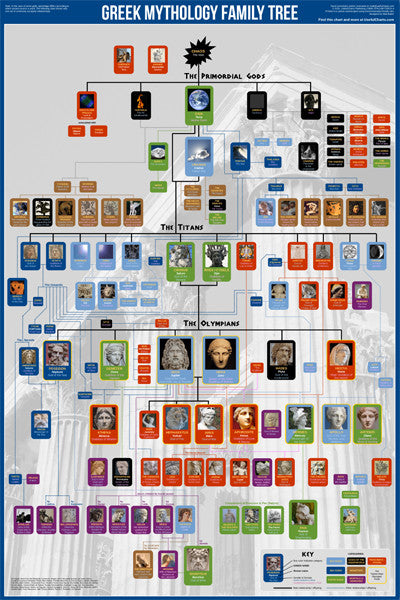
Greek Mythology Family Tree Wall Chart Premium Reference Poster - Useful Charts
Item # UC-04
Biblical Family Tree and Historical Timeline Wall Chart Premium Reference Poster - Useful Charts
Item # UC-17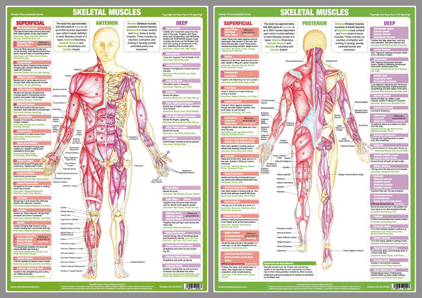
Major Skeletal Muscles Anatomy Wall Chart Poster Set (2 Posters) - Chartex Ltd.
Item # CX-MAJORMUSC-2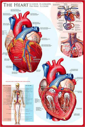
Anatomy of The Human Heart Wall Chart Poster - Eurographics
Item # EU2450-0257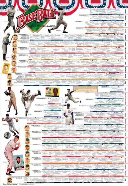
History of Major League Baseball Wall Chart Poster (to 2016) - Vanguard Sports Publishing
Item # V002
Islamic Prophets Family Tree Wall Chart Premium Reference Poster - Useful Charts
Item # UC-18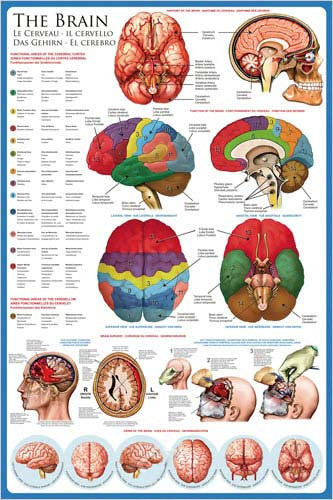
Anatomy of The Human Brain Wall Chart Poster - Eurographics
Item # EU2450-0256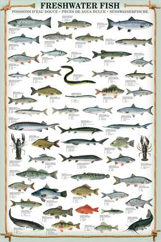
Freshwater Fish (53 Species) Wall Chart Poster - Eurographics
Item # EU2450-0312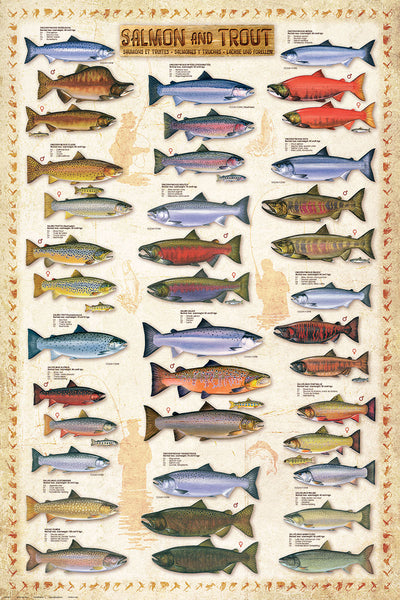
Salmon and Trout Fishing Wall Chart (17 Species) Poster - Eurographics
Item # EU2450-0311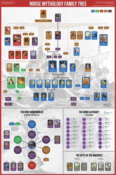
Norse Mythology Family Tree Wall Chart Premium Reference Poster - Useful Charts
Item # UC-05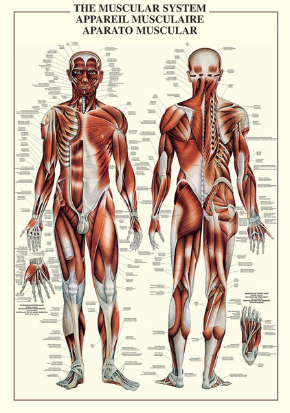
The Muscular System Human Anatomy Wall Chart Reference Poster - Ricordi Arte/Eurographics
Item # EU2450-4460
Evolutionary Tree of Life Wall Chart Premium 24x36 Reference Poster - Useful Charts
Item # UC-12
The Great Composers of History Classical Music Wall Chart Poster - Eurographics Inc.
Item # EU2450-2007
The Great Chile Poster 2-Poster Combo (Fresco & Seco) - American Image
Item # IC-CHILEPOSTERS
Timeline of U.S. History (American History from 1565 to Present) Premium Wall Chart Poster
Item # UC-03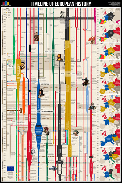
Timeline of European History (History from 14th Century CE to Present) Premium Wall Chart Poster
Item # UC-02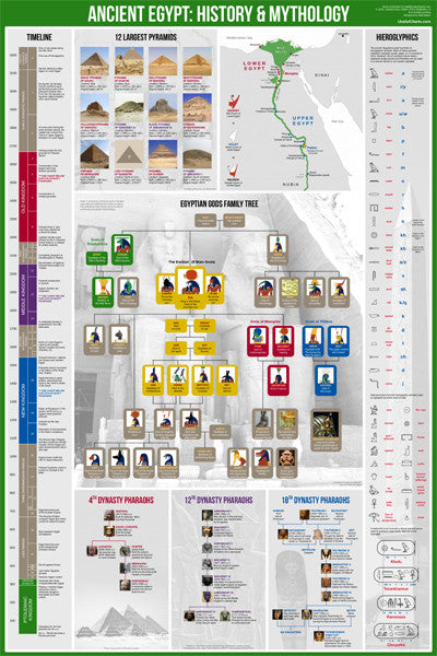
Ancient Egypt History and Mythology Premium Timeline Educational Wall Chart Poster
Item # UC-06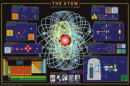
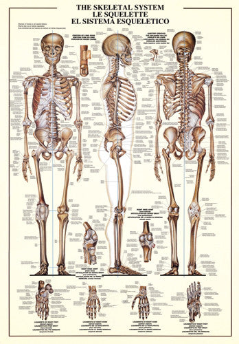
The Skeletal System Human Anatomy Large 27x39 Wall Chart Poster - Nuova
Item # EU2450-3970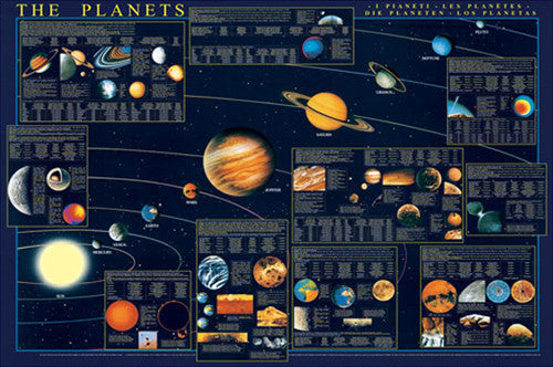
The Planets of the Solar System Science Educational 27x39 Poster - Eurographics Inc.
Item # EU2450-4790
The Bill of Rights (First Ten Amendments to the United States Constitution) Poster - Trends International
Item # CN6908-13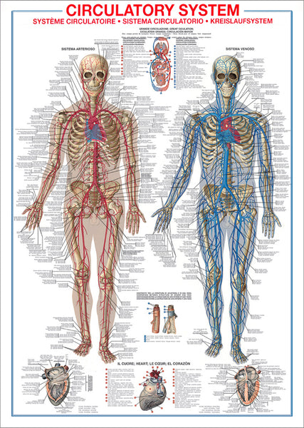
The Circulatory System Human Anatomy Wall Chart 27x39 Reference Poster - Ricordi Arte/Eurographics
Item # EU2450-4940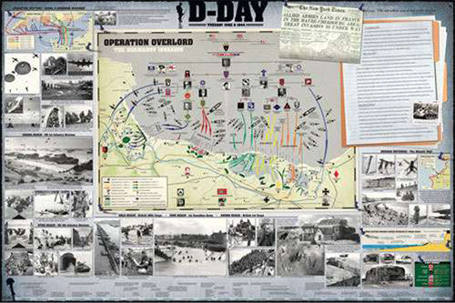
D-Day WWII Normandy Invasion Military History Wall Chart Poster - Eurographics Inc.
Item # EU2450-0295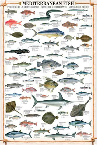
Mediterranean Fish Wall Chart Poster (61 Saltwater Species) Poster - Eurographics
Item # EU2450-0315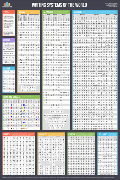
Writing Systems of the World Educational Reference Wall Chart Poster - Useful Charts
Item # UC-08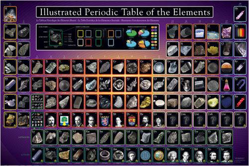
Illustrated Periodic Table of the Elements Poster - Eurographics Inc.
Item # EU2450-0258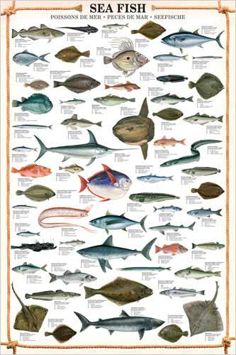
Sea Fish Wall Chart (59 Saltwater Species) Poster - Eurographics
Item # EU2450-0313
The Wisdom of Albert Einstein Poster (22 Quotations) - Eurographics Inc.
Item # EU2400-0287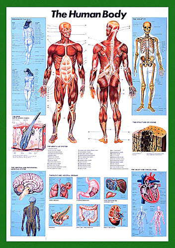
The Human Body Anatomy Large 27x39 Wall Chart Poster - Nuova Arti Grafiche
Item # EU2450-1570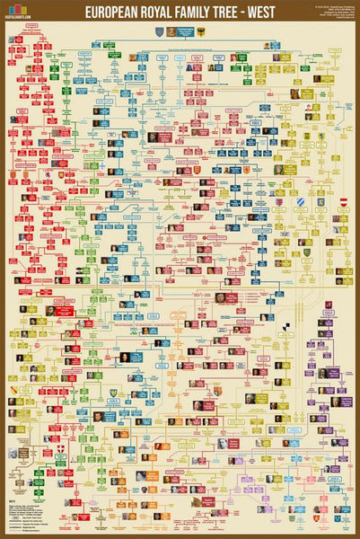
Western European Royal Family Tree Wall Chart Premium Reference Poster - Useful Charts
Item # UC-15
Roman Emperors Family Tree Wall Chart Premium Reference Poster - Useful Charts
Item # UC-09
History of World War II Educational Wall Chart Poster - Vanguard Publishing
Item # V005
Proverbidioms by T.E. Breitenbach Official 22x28 Poster Print
Item # BREIT-01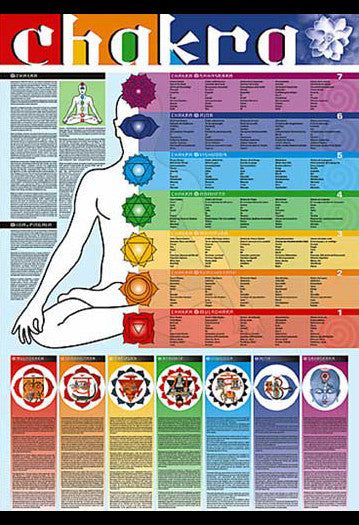
Chakras of the Human Body Yoga Wall Chart - Ricordi Arte 2005
Item # EU2450-4960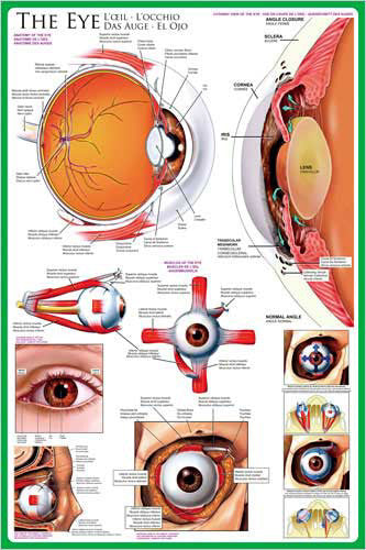
Anatomy of The Human Eye Wall Chart Poster - Eurographics Inc.
Item # EU2450-0260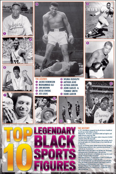
Top 10 Legendary Black Sports Figures Historical Wall Chart Poster - African-American Athletes
Item # EU2450-0003
Child Choking First Aid Wall Chart Poster (AHA/ARC Guidelines)- Fitnus Corp.
Item # FI-FA05
History of the American CIVIL WAR Educational Wall Chart Poster - Vanguard
Item # V006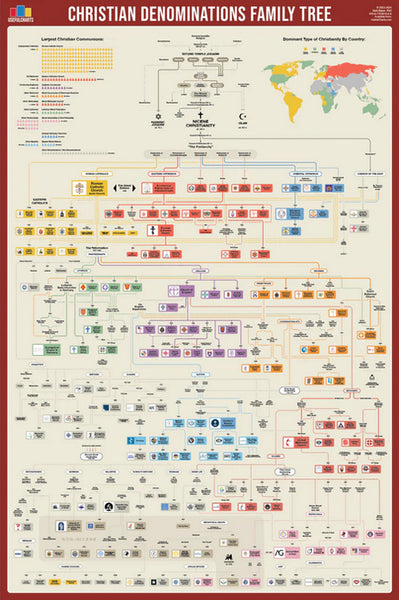
Christian Denominations Family Tree and Historical Timeline Wall Chart Premium Reference Poster - Useful Charts
Item # UC-27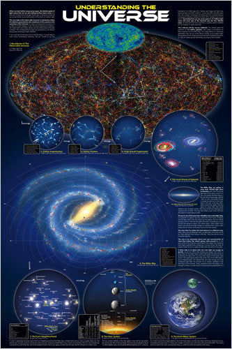
Understanding the Universe Educational Wall Chart Poster - Eurographics Inc.
Item # EU2450-0279
Vitamins Food Nutritional Wall Chart Poster - Eurographics
Item # EU2450-1016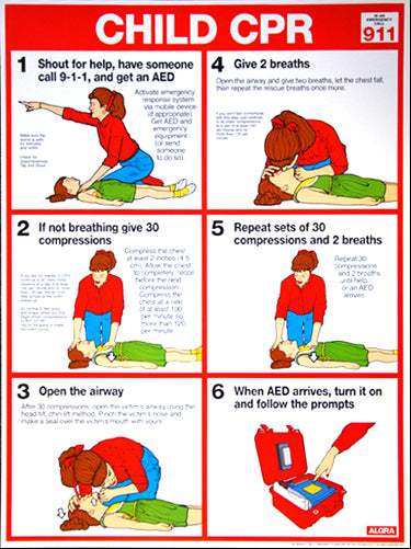
Child CPR First Aid Wall Chart Poster (2017 AHA Guidelines) - Fitnus Corp.
Item # FI-FA02A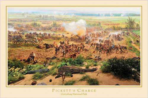
Gettysburg Cyclorama "Pickett's Charge Detail" Civil War Poster - Eurographics Inc.
Item # EU2400-0281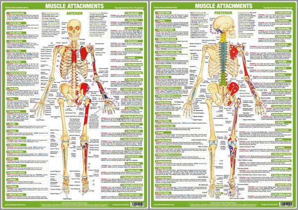
Major Muscle Attachments Human Physical Anatomy 2-Poster Combo Set - Chartex Ltd
Item # CX-MUSCATT-2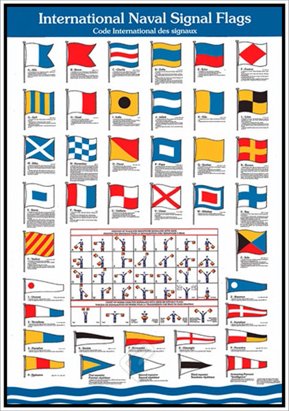
International Naval Signal Flags for Yachting and Sailing Wall Chart Poster - Eurographics Inc.
Item # EU2450-2740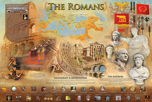
The Romans Classical Civilization Roman Empire Educational Historical Poster - Eurographics Inc.
Item # EU2450-0584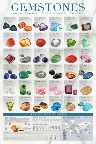
Gemstones (Geology Minerals for Jewelry) Wall Chart Poster - Eurographics Inc.
Item # EU2450-0582
Asian Royal Family Trees (China, Japan, Korea, Mongols) Wall Chart Premium Reference Poster - Useful Charts
Item # UC-10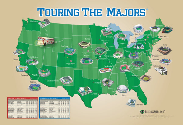
Touring the Majors MLB Ballparks Map of America Poster - Grand Slam Enterprises
Item # GSM-01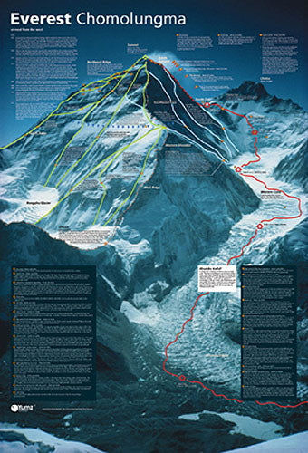
Mount Everest Revealed Mountain Climbing Wall Chart Poster - Yumz
Item # YU-01
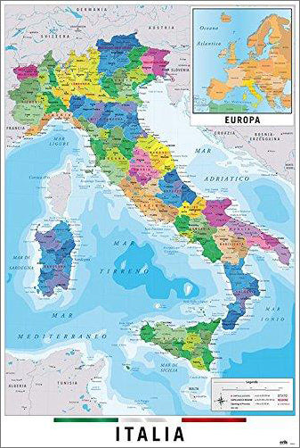
Map of Italy Italia Wall Chart Poster (Regions, Capitals, Cities, Roads, Rivers, etc.) - Grupo Erik
Item # GE-GPE5125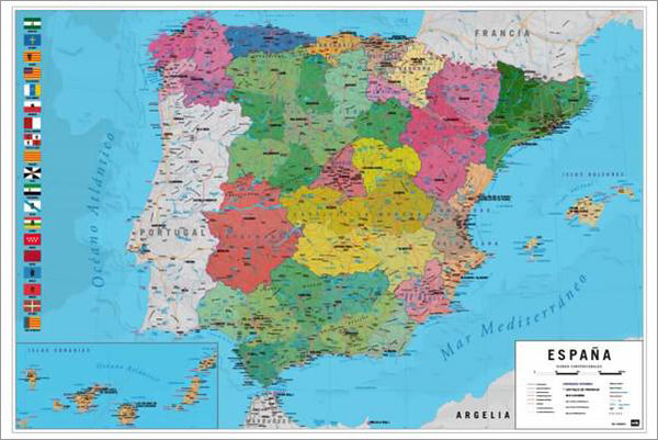
Map of Spain Wall Chart Poster (Regions, Capitals, Cities, Roads, Rivers, etc.) - Grupo Erik
Item # GE-GPE5030
Map of The United States of America USA 24x36 Wall Poster - Eurographics Inc.
Item # EU2400-0788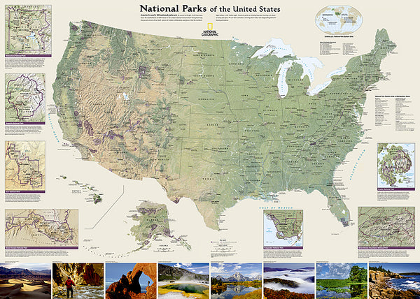
National Parks of the United States National Geographic 30x42 Wall Map Poster - NG Maps
Item # NG-RE01020599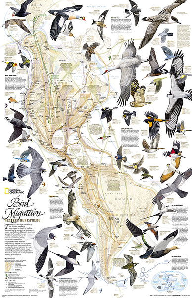
Bird Migration of the Western Hemisphere National Geographic 20x31 Wall Map Poster - NG Maps
Item # NG-RE01020304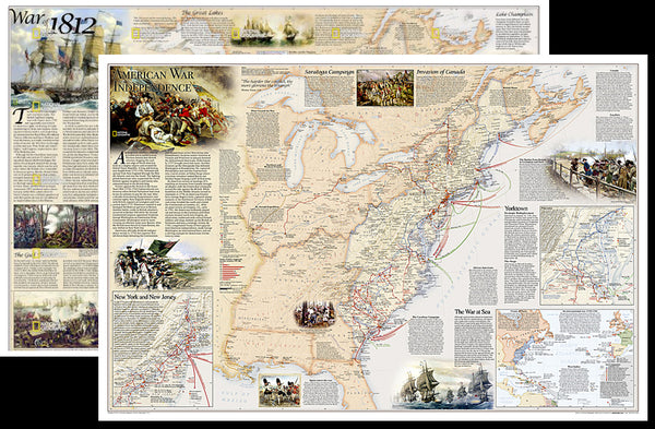
American Revolutionary War/War of 1812 National Geographic 24x36 History Wall Map 2-Sided Poster - NG Maps
Item # NG-RE01020603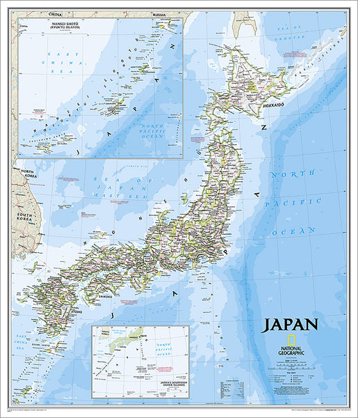
Map of JAPAN National Geographic Classic Edition 25x29 Wall Map Poster - NG Maps
Item # NG-RE01020670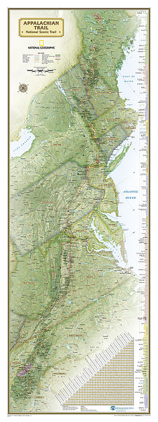
The Appalachian Trail National Geographic 18x48 Hiking Wall Map Poster - NG Maps
Item # NG-RE01020715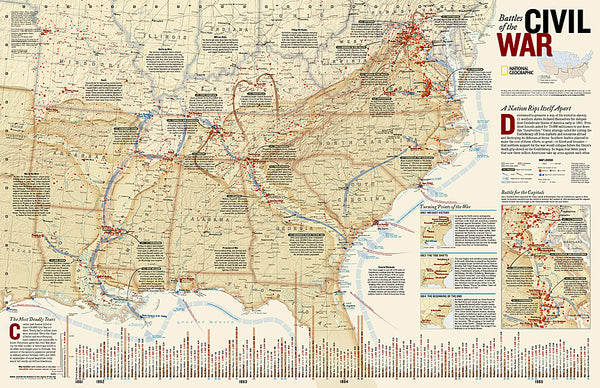
Battles of the American Civil War National Geographic 24x36 Wall Map Poster - NG Maps
Item # NG-RE00620346
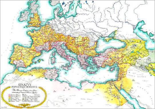
Map of the Roman Empire circa 180 CE Premium Wall Poster - Useful Charts
Item # UC-13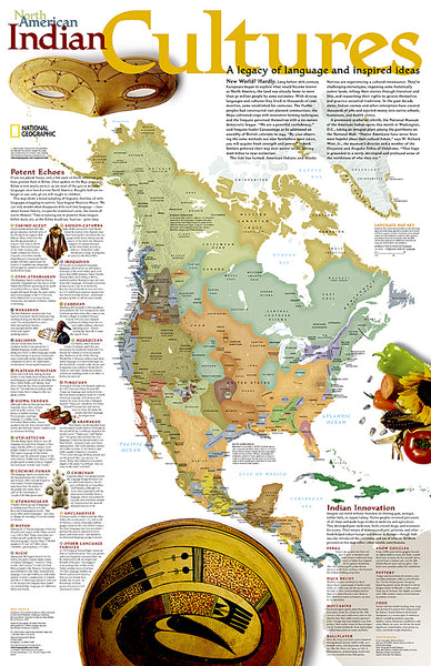
North American Indian Cultures National Geographic 24x36 Wall Map Poster - NG Maps
Item # NG-RE00620319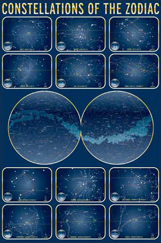
Constellations of the Zodiac Astronomy Wall Chart Poster - Eurographics Inc.
Item # EU2450-4450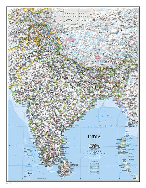
Map of INDIA National Geographic Classic Edition 23x30 Wall Map Poster - NG Maps
Item # NG-RE00620546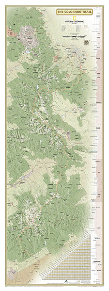
The Colorado Trail National Geographic 18x48 Hiking Wall Map Poster - NG Maps
Item # NG-RE01021199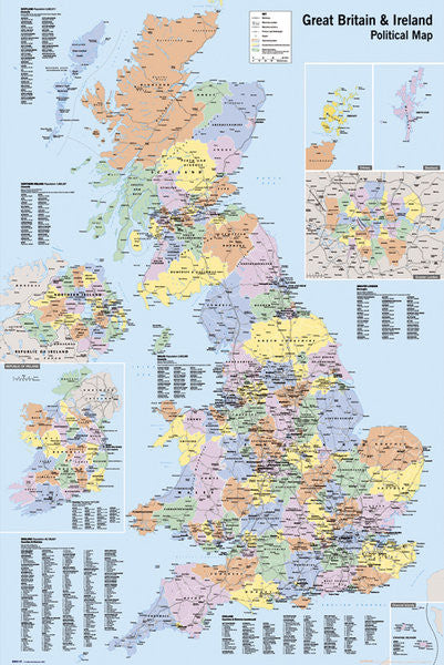
Map of Great Britain and Ireland Wall Poster - GB Eye Ltd.
Item # GB-GN0147
Planetary Visions Physical Map of the World (Miller Cylindrical Projection) Wall POSTER - GB Eye
Item # GB-GN0394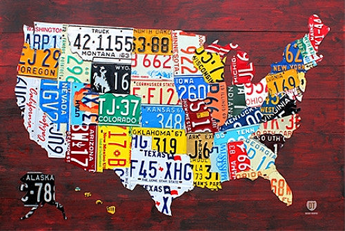
License Plates Map of the United States of America Poster - PosterService Inc.
Item # PS-10205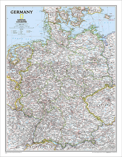
Map of Germany National Geographic Classic Edition 23x30 Wall Map Poster - NG Maps
Item # NG-RE00602814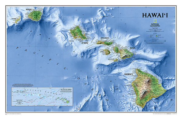
Map of Hawaii National Geographic Classic Edition 22x35 Wall Map Poster - NG Maps
Item # NG-RE00602061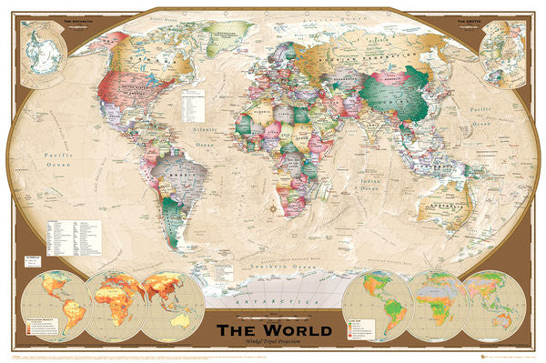
Wall Map of The World Poster (Winkel Tripel Projection) - GB Eye Ltd.
Item # GB-GN0532
Flags of the World (197 Countries) Educational Wall Chart 24x36 Poster - Eurographics Inc.
Item # EU2450-0128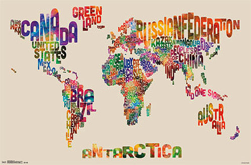
Map of the World Typography Text Map Poster by Michael Tompsett - Trends
Item # CN13480-14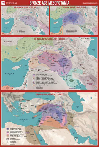
Bronze Age Mesopotamia (1700-600 BCE) Maps Premium 24x36 Reference Poster - Useful Charts/World History Encyclopedia
Item # UC-23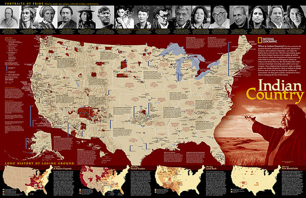
Indian Country Native Cultures of the United States National Geographic 20x31 Wall Map Poster - NG Maps
Item # NG-RE00620315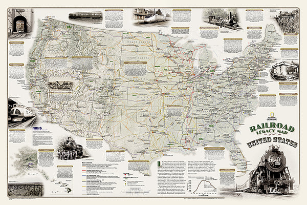
Railroad Legacy of the United States National Geographic 24x36 Wall Map Poster - NG Maps
Item # NG-RE01020718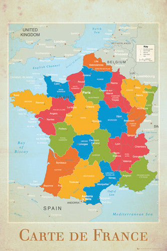
Map of France Wall Chart Poster (Regions, Capitals, Cities, Rivers, etc.) - GB Eye
Item # GB-GN0779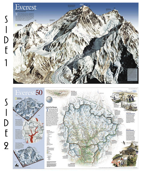
Mount Everest National Geographic 30x47 Wall Map 2-Sided Poster - NG Maps
Item # NG-RE00620098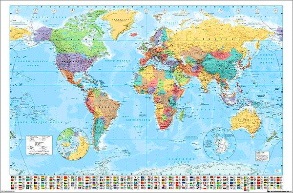
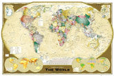
Map of the World 22x34 Wall Poster - Collins Bartholomew Ltd.
Item # CN10157-19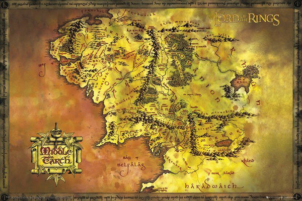
Map of Middle Earth Poster (from J.R.R. Tolkien's The Lord of the Rings) - GB Eye Inc.
Item # SB-GB-FP2647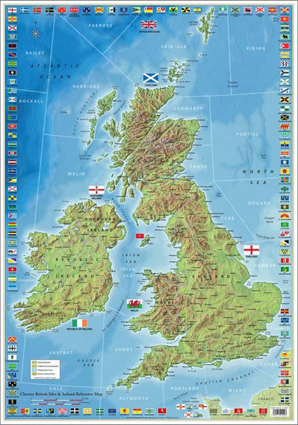
The Ultimate British Isles and Ireland Wall Map Poster w/120 County Flags - Chartex Inc. (UK)
Item # CX-1902A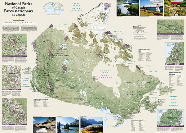
National Parks of the Canada National Geographic 30x42 Wall Map Poster - NG Maps
Item # NG-RE01020680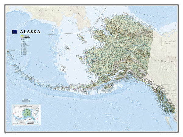
Map of Alaska National Geographic Classic Edition 30x40 Wall Map Poster - NG Maps
Item # NG-RE01020587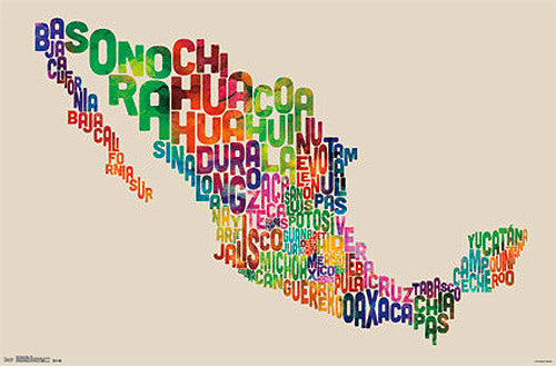
Map of Mexico Typography Text Map Wall Poster by Michael Tompsett - Trends International
Item # CN13491-14-L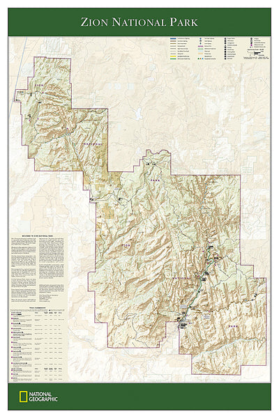
Zion National Park National Geographic 24x36 Wall Map Poster - NG Maps
Item # NG-RE01020343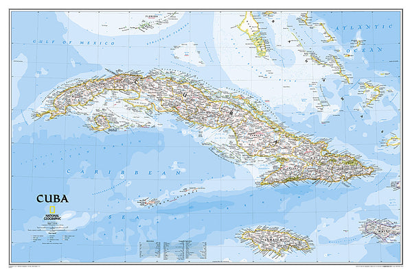
Map of CUBA National Geographic Classic Edition 24x36 Wall Map Poster - NG Maps
Item # NG-RE01020614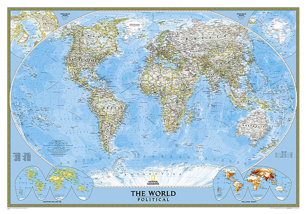
Map of the World National Geographic Classic Edition 30x43 Wall Map Poster - NG Maps
Item # NG-RE00622005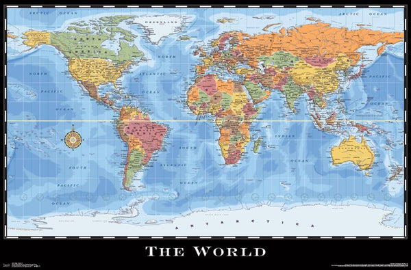
World Map Wall Poster (Modern Political) by Eureka Cartography - Trends International 2017
Item # CN15214-17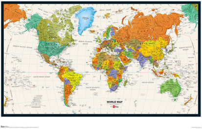
Map of the World Wall Poster - Trends International Inc.
Item # CN6131-09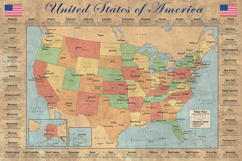
United States of America "States and Capitals" Wall Map Poster - Pyramid America
Item # PP-PAS0353
Map of Korea THE KOREAN PENINSULA National Geographic Classic Edition 23x35 Wall Map Poster - NG Maps
Item # NG-RE01020740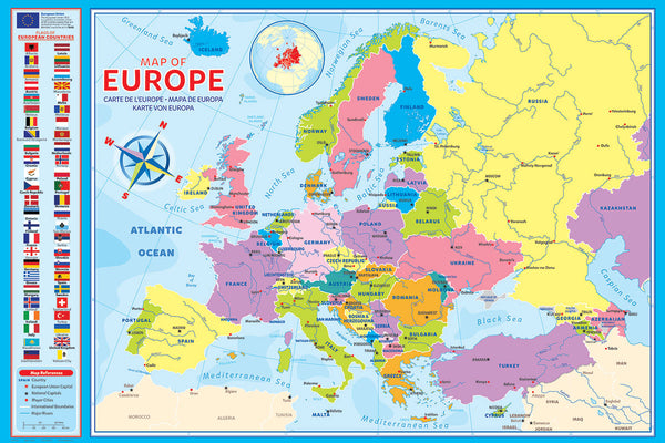
Map of Europe (50 Nations) 24x36 Wall Poster - Eurographics Inc.
Item # EU2400-5374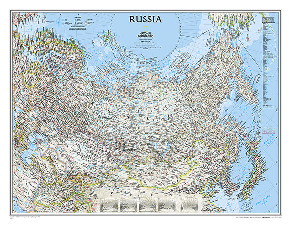
Map of RUSSIA National Geographic Classic Edition 23x30 Wall Map Poster - NG Maps
Item # NG-RE00622091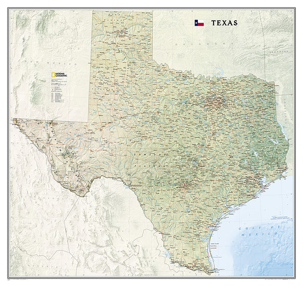
Map of TEXAS National Geographic Classic Edition 38x40 Wall Map Poster - NG Maps
Item # NG-RE01020408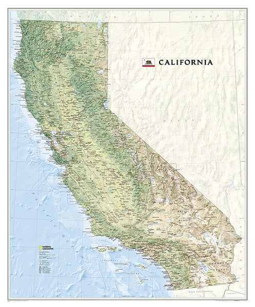
Map of California National Geographic Classic Edition 33x40 Wall Map Poster - NG Maps
Item # NG-RE01020371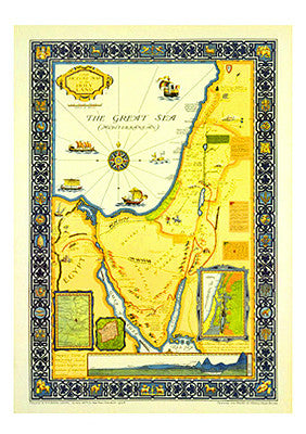
Picture Map of the Holy Land (Harold Brown c.1928) Extra-Large Israel Poster
Item # AAC-AM7021